123
Sligo Connecting Ireland Maps And Network Table Web
Regional Public Transport Ireland Map2026
Slieve Gullion Mountain Information
Mountain (climbing) weather forecasts for 2 elevations of Slieve Gullion, Mourne Mountains, Ireland Ranges, United Kingdom. Detailed 6 day mountain weather forecasts for climbers and mountaineers planning expeditions.
Original link
The National Transport Authority (NTA) addresses this exact structural gap between Sligo and the Mayo border through specific, regional planning documents.
Rather than viewing the entire country, you can isolate the specific corridor maps showing local vs. regional bus structures for this exact "blank" geographic space:

Local Infrastructure & Transit Gap Maps

  • West Sligo Local Route Infrastructure Strategy: To see the specific layout of transit lines and planned deviations running west out of Sligo Town toward the Mayo border, use the Sligo Public Transport Strategy Network Map PDF. Page 1 shows how routes hug the coast or the main roads, leaving the rural gap inland toward Bonniconlon completely clear of fixed lines. [1, 2]
  • The Mayo/Bonniconlon Border Integration: To view the map from the western side looking back toward Sligo, examine the Mayo Connecting Ireland Regional Strategy Map PDF. This details where the Ballina/Bonniconlon lines terminate, visualizing the empty transit space between the two county networks.

Understanding the Map Structure

When you open the Sligo Strategy Document, look closely at the West/South-West quadrant:
  • The Coastal Line: You will see a prominent route (Route 458) running directly along the coast toward Dromore West.
  • The Blank Inland Pocket: The entire triangular geographic zone south of that coastal line, moving west through the Ox Mountains toward Bonniconlon, is left entirely blank of scheduled routes on the map. This visually confirms that the NTA classifies this area strictly under "Demand Responsive Transport" (non-mapped booking services) rather than fixed local bus paths. [1, 3, 4]
Would you like help identifying the closest active bus stops on the edge of that blank zone, or do you want to trace the specific regional road routes (like the R294) that define the boundaries of that area?
Your observation is spot on: the Ox Mountains (Sliabh Gamh) are the primary reason for that large blank space on the local map. [1, 2]
There are no direct local buses connecting Ballinacarrow (in County Sligo) and Bonniconlon (in County Mayo) because the Ox Mountain range forms a massive, rugged, and boggy geographic barrier directly between them. [2, 3]

The Geographic Barrier

  • Unsuitable Road Infrastructure: To drive directly from Ballinacarrow to Bonniconlon, you have to cut straight through the high country of the Ox Mountains. The terrain consists of open blanket bog and steep slopes. The local mountain passes are narrow, winding, single-track country lanes completely unsuited for standard public transit buses. [2, 3]
  • Lack of Intermediate Passenger Demand: Because the mountain core is vast, wet, and largely uninhabited, there are no villages along a direct mountain path to justify a scheduled bus route. [2]

How the Bus Routes "Skirt" the Mountains

Instead of crossing the mountains, the National Transport Authority (NTA) funnels public transit entirely around the perimeter of the range: [4]
  1. The Southern Route (The N17 Corridor): Mainline and regional services from Ballinacarrow run south down the flat plain via the N17 toward Tubbercurry.
  2. The R294 Connection: From Tubbercurry, vehicles must head west along the R294 regional road, which skirts the southern base of the Ox Mountains past Lough Talt before finally reaching Bonniconlon and Ballina. [1, 5]
Because these two settlements sit on entirely different sides of the mountain slopes, anyone trying to use public transport between them must travel down to Tubbercurry or Ballina to transfer, bypassing the blank mountain interior entirely. [5, 6]
If you are looking to travel between these two specific areas, would you like to map out a driving route through the Ox Mountain Scenic Drive, or do you need the connecting timetables via Tubbercurry? [5, 7]
In 
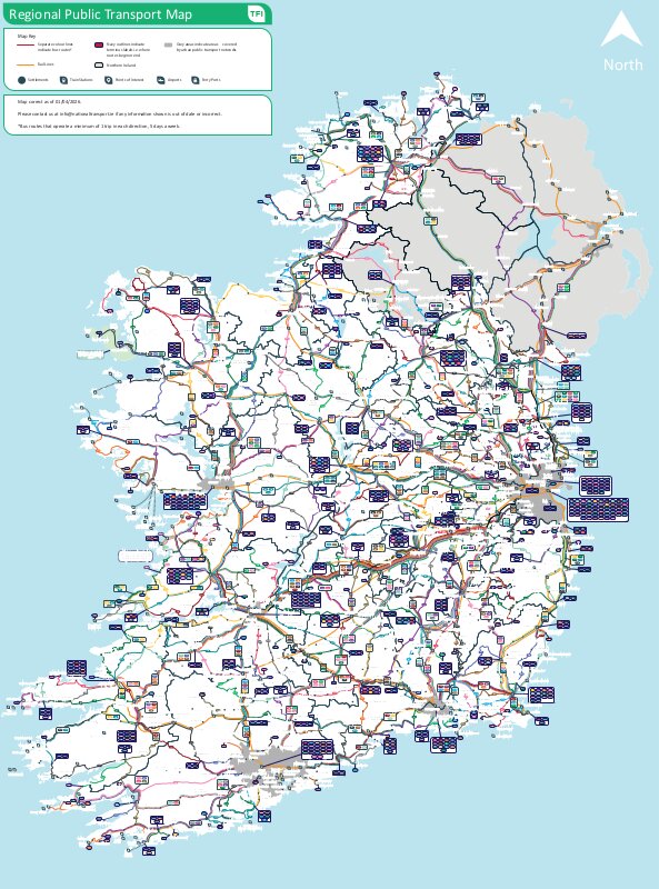
Ireland, the inner core of mountain ranges, vast blanket bogs, and isolated offshore islands are the primary regions that do not have any scheduled bus services.
While the National Transport Authority (NTA) aims to connect every village with at least one weekly service under the Connecting Ireland Rural Plan, major geographic barriers create permanent blanks on the public transport map.

1. Rugged Mountain Interior Zones

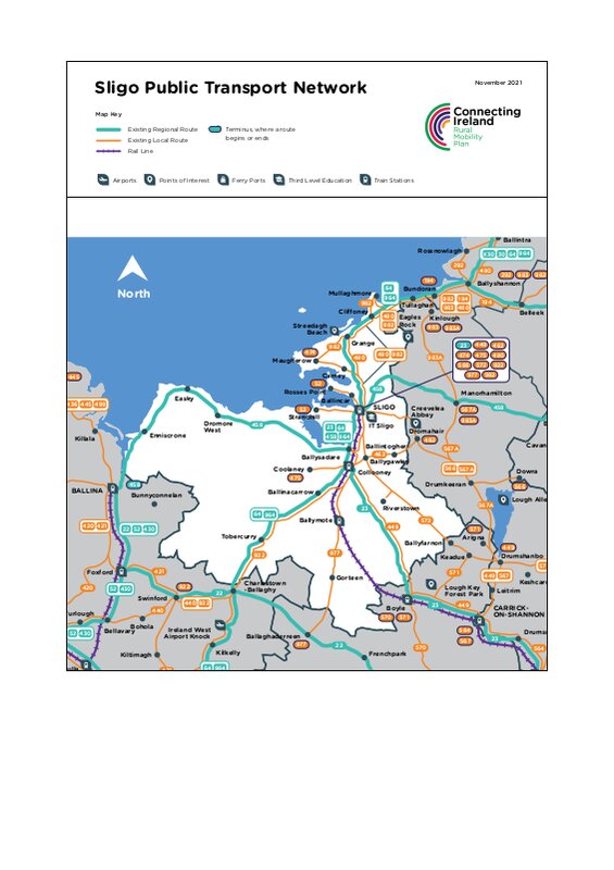
As you noticed with the Ox Mountains (Sliabh Gamh) between Ballinacarrow and Bonniconlon, high-altitude mountain ranges lack buses due to steep terrain, narrow single-track roads, and zero population density. Similar unserved mountain interiors include:
  • The MacGillycuddy's Reeks & Black Valley (Kerry): Home to Ireland's highest peaks, these areas feature roads like the Gap of Dunloe that are too narrow and dangerous for buses.
  • The Nephin Beg Range & Wild Nephin Wilderness (Mayo): One of the most remote, unpopulated areas in Western Europe, consisting of vast, roadless boglands.
  • The Derryveagh Mountains & Poisoned Glen (Donegal): Rugged, rocky terrains where roads only skirt the perimeter.
  • The Wicklow Mountains Interior: While buses serve peripheral towns like Blessington or Laragh (Glendalough), the high military roads and peat bogs crossing the center have no public transport.

2. Isolated Offshore Islands

Many inhabited and uninhabited islands off the West Coast have no bus infrastructure due to their size and lack of a vehicle-accessible land connection. Transport to these areas is strictly limited to seasonal or year-round ferries and small planes. Examples include:

The Blasket Islands (Kerry): Completely uninhabited and rugged.
Tory Island and Inishbofin (Donegal): Small, remote islands where residents and visitors walk or use private vehicles.
Clare Island and Inishturk (Mayo): Served by passenger ferries from Roonagh Pier, but lacking internal public bus routes.

3. Deep Peatlands and Peninsular Outer Edges

Certain low-density coastal sections or deep bog terrains lack traditional fixed routes:
  • The Bog of Allen (Midlands): Vast tracts of industrial and wild peat bogs have roads running around them, but the interiors are completely blank.
  • Remote Atlantic Peninsulas: While the main loops of peninsulas like the Dingle, Iveragh (Ring of Kerry), or Beara peninsulas have tourist or local buses, the dead-end roads leading to isolated fishing coves or cliffs do not.

How the State Addresses These "Blank" Spaces

Instead of running empty, large buses on fixed timetables through these areas, the state relies on Local Link Demand Responsive Transport (DRT). These are small, flexible shuttle buses or hackneys that do not show up on a standard transit map. They only enter these remote rural pockets if a resident pre-books a door-to-door collection at least a day in advance through regional offices like TFI Local Link Mayo or TFI Local Link Donegal Sligo Leitrim.
Would you like to explore how to book one of these demand-responsive vehicles, or are you looking for scenic driving routes through these unserved wilderness areas?